June 2 – June 4
This is one of the most important stories about the Ice Age Flood. We have been seeing the effects of it and now we explored the area where the ice dam was.
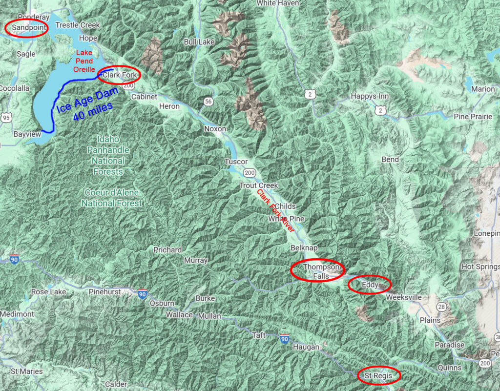
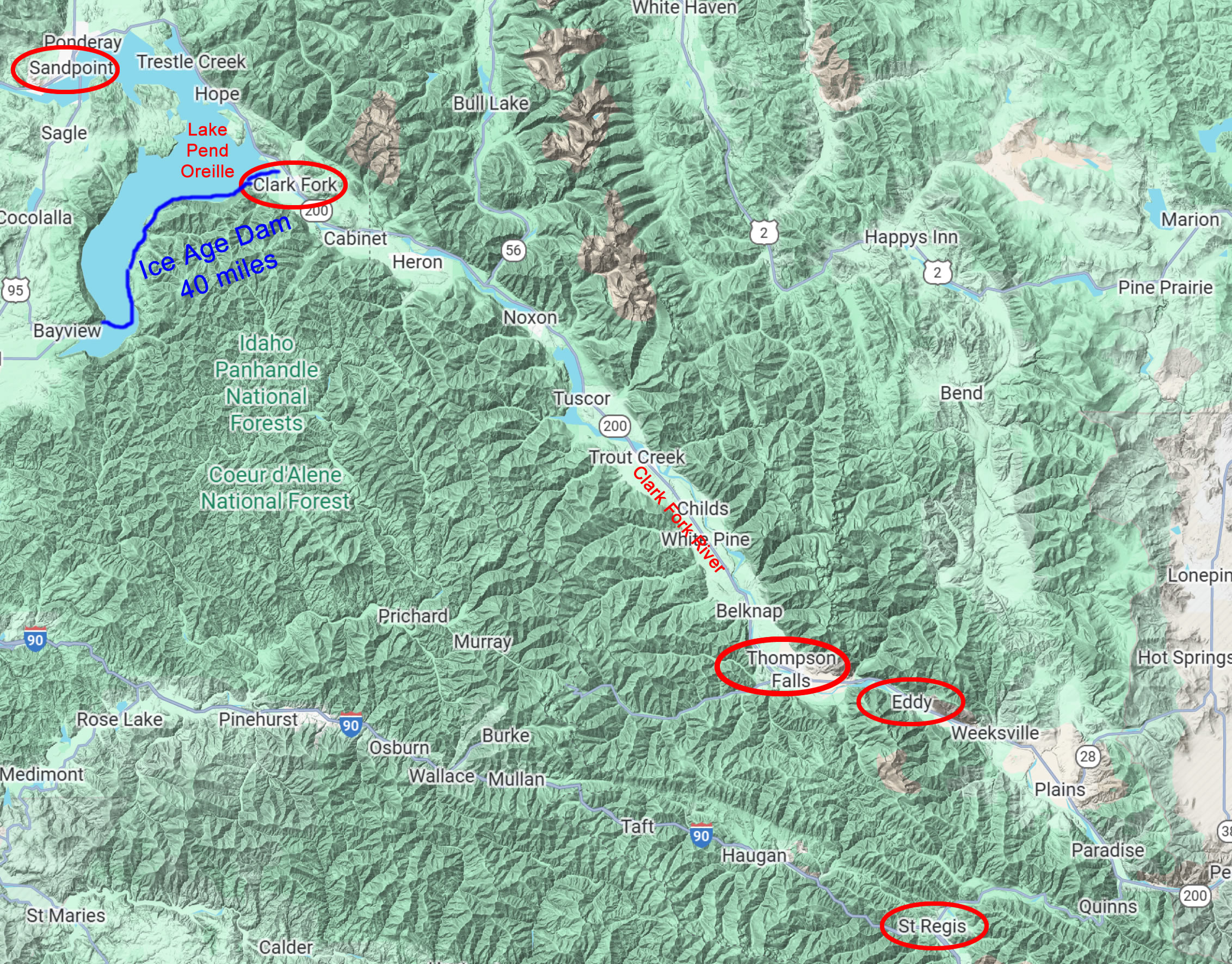
We left Missoula and drove north on I-90 following the Clark Fork River. At St. Regis we headed north on SR135 then we went north on SR200 still following the Clark Fork which was joined by the Flathead River, a little before Paradise. We passed through the Eddy Narrows, Thompson Falls, the town of Clark Fork, and Lake Pend Oreille (“Pond o-Ray”) ending up at Sandpoint ID where we parked at the Bonner County Fairgrounds. It was a long drive and we didn’t make many stops because we were in our RVs. We took the next day off so Myrna could do some repairs on her RV while Loris and I went to the Bonner County Historic Museum.
On June 4th we drove back down SR200 in Myrna’s car to see all the things we had passed. We wanted to go back to the Eddy Narrows, we had seen the sign on our way up but hadn’t stopped. We passed some interesting poster boards along the way. You can see where Eddy is on the map and the rock walls of the canyon got very narrow and that forced water to back up on the SE side and flow faster on the NW side. You can see the rhythmites (layers of sediment) on the rocks caused by the floods. We stopped at Thompson Falls and visited the Old Jail Museum, a place that had housed only women until the 1970s! The Thompson Falls Dam, in operation since 1915, was constructed atop the original falls. In 2010, a fish ladder was completed consisting of 48 pools, each one foot higher than the last, enabling native fish, including bull trout to pass the 913-foot Thompson Falls Dam for the first time in nearly a century. I walked across a bridge to Island Park next to the dam, to get better photos of the dam and the fish ladder.
Our next stop was the town of Clark Fork ID, one of the focal points of the Ice Age Floods, where the Ice Dam was formed 12,000-15,000 years ago to create the huge lake Missoula in what is now Montana. This period was at the end of the last ice age, when the glaciers advanced to create the Ice Dam and then receded to cause it to break down. The experts think the Ice Dam broke every 50 to 100 years and formed again up to 100 times causing the huge amount of water to shape the terrain in Montana, Idaho, Washington, and even Oregon. We took a side road going north from Clark Fork looking for rhythmites which showed the layers of sediment deposited repeatedly by the floods. It took us awhile to find them because they were at the top of the canyon walls and hidden by trees. We stood next to the river and looked up, trying to imagine the water of the lake 2000′ overhead! Here’s a good explanation: Rhythmites. Be sure to watch the video.
* The Ice Dam line above may not be accurate, I couldn’t find a good example

This terrain map shows you the towns we drove thru from St. Regis MT (not on map: Missoula MT south on I-90) and shows you where the river paths were carved (light green) between the mountains. Remember Glacial Lake Missoula was 1000′ to 2000′ deep (!!) so the mountains were what contained it.
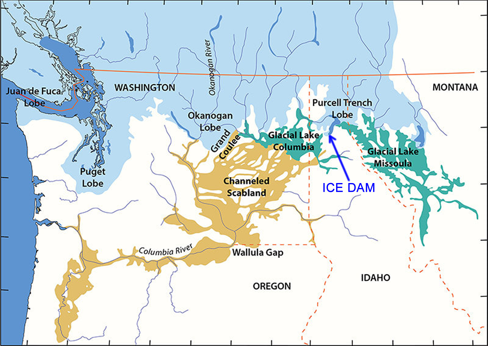
When part of the Cordilleran Ice Sheet pushed into the Lake Pend Oreille area of the Idaho Panhandle, it created an ice dam over 40 miles wide and 3000 feet thick, that blocked the Clark Fork River drainage and impounded Glacial Lake Missoula. At its largest, the lake was more than 2,000 feet deep at the ice dam and held over 500 cubic miles of water,
The ice dam reached east up the Clark’s Fork to Cabinet, Montana, and southward around the mountain to Bayview, Idaho on the south tip of Lake Pend Oreille in Farragut State Park. Here, the ice sheet stood over 2,000 feet (610 m) and 25 miles (40 km) south of Lake Missoula.
I think I got carried away with all these details, but I just couldn’t resist. I kept having questions, and the more I dug in the more fascinated I was. In the next Travelogue we go to Farragut State Park where the floods began.


")


Thompson Falls Dam